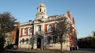
Our final walk was around Y Waun and Glyn Ceiriog AKA Chirk and the Ceiriog Valley on the Welsh/English border. Chirk is thought to be a corruption of church as the original Welsh name was in fact “Eglwys-y-Waun” (Church on the Moor), with the Welsh name now shortened to “Y Waun”. Chirk was a staging post on the London to Holyhead Mail Road.
On what turned out to be a beautiful, dry, settled, sunny, hot day we parked up at The Davies' Gate of Chirk Castle, a Marcher fortress dating to 1310, built by King Edward I. It overlooks the Ceiriog Valley and Berwyn Mountains to the south and Clwydian Range to the north. The estate parkland is a tranquil Site of Special Scientific Interest with veteran trees and an important habitat for fungi, bats and deadwood invertebrates. We followed paths through the estate starting on the Llywyn-y-cil walk and then joining the woodland walk until it brought us round to the castle.
After lunch we proceeded to visit part of the castle gardens. The garden has modern and old-fashioned roses, a woodland garden, herbaceous borders, alpine rockery and Yew topiary. There are good views of the surrounding area, particularly to the south of here.
After leaving the gardens, we joined a(nother) section of the Offa's Dyke path, past “The Oak at the Gates of the Dead” or “Crogen Oak”, a tree thought to be more than 1000 years old. It is located on the site of the 1165 Battle of Crogen and near the burial site of the dead from the battle. The battle took place during Henry II's 1165 campaign against an alliance of Welsh Princes' led by Owain ap Gruffudd who was the grandfather of Llywelyn the Great. Owain ap Gruffudd (born c. 1100) was King of Gwynedd, North Wales, from 1137 until his death in 1170. He was called "Owain the Great" (Welsh: Owain Mawr) and the first to be styled "Prince of Wales".
Crossing the Afon Ceiriog (River Ceiriog) and the Welsh/English border, we had a steep uphill climb through a field with good views back towards the castle. This is one of three places where Offa's Dyke path meets the Shropshire Way.
From here we dropped down into Bronygarth where we had to take a detour following part of the footpath being washed away. At this point on the Offa's Dyke Path and the Shropshire Way, it is also part of the Llwybr Maelor Way and the Ceiriog Valley Walk. The former is another long distance footpath. We followed the valley east through Pentre Wood to Pont-Faen (stone bridge) where we crossed the border once again.
We stopped for a tea and cake break before proceeding to Chirk Aqueduct and Viaduct. The Chirk Aqueduct is a 70ft/21m high, 710ft/220m long navigable aqueduct of the Llangollen Canal, striding across the border. Adjacent to it is the Chirk Railway Viaduct. The Aqueduct is part of the Pontcysyllte Aqueduct and Llangollen Canal World Heritage Site and was built between 1796 & 1801 by William Jessop and Thomas Telford; it has ten circular masonry arches. The Viaduct was built by Henry Robertson in 1846-48 and opened in 1848; it has ten spans with round arches and stands 30ft/10m above the Aqueduct. Both can be seen from the Aqueduct footpath/towpath.
Just down the towpath is “Chirk Tunnel”, known locally as “The Darkie” due to being pitch black, was one of the first in the UK to have a towpath and was built between 1795-1802. The walk from here took us back up through woods to the castle gates where we'd parked.


